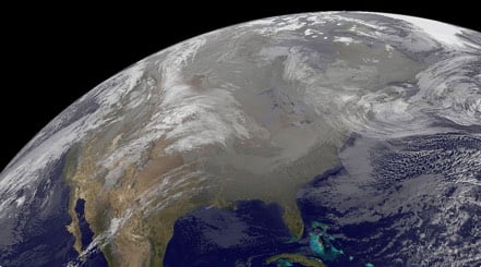
Just days after snow and ice glazed the Mid-Mississippi Valley to the Mid-Atlantic, a new winter wallop is preparing to aim for the South to round out the work week.
Cold air continues to billow southward across the central and eastern U.S., leading to temperatures that are struggling to climb past the freezing mark. At the same time, an area of low pressure is starting to come together across Texas, and will motor through the Mid-South and into the Carolinas. The result will be a rare winter storm across the southern states, capable of bringing travel to a standstill today and Friday.
Winter Storm Warnings stretch from northeastern Texas to southern Indiana, central Kentucky, central Tennessee, and northern Alabama. This includes the Dallas-Fort Worth metroplex, Shreveport, La., Little Rock, Ark., Tupelo, Miss., Cape Girardeau, Mo., Memphis, Tenn., Paducah and Louisiville, Ky., and Nashville, Tenn. Winter Weather Advisories stretch from New Mexico to the lower Ohio Valley, including Oklahoma City, St. Louis, and Indianapolis. Winter Storm Watches extend eastward across northern Georgia, eastern Tennessee, through the Carolinas and into southeastern Virginia. This includes cities such as Atlanta, Knoxville, Tenn., Charlotte and Raleigh, N.C., Greenville, S.C., and Richmond, Va.
Snow and ice developed overnight across western Texas, with additional areas of rain, snow, and sleet expected to expand across northern and western Texas by this afternoon. This pattern will be repeated to the east, with a sloppy snow-and-ice mess expected to last through Friday morning in the lower Mississippi Valley and through Friday night in the Southeast. As much as 2 to 5 inches of snow can be expected within the warning area, in addition to 0.05 to 0.10 inches of ice. Localized snow amounts of 6 to 8 inches will be possible where it stays all snow across portions of eastern Oklahoma into central Arkansas and southeastern Missouri. Outside of this core, an inch or two of snow will accumulate on everything through Friday.
Meanwhile, moderate to locally heavy rainfall will occur on the warm side of this area of low pressure. Rainfall totals of 1 to 3 inches will be possible from southeastern Texas to southern Mississippi. This may lead to localized flooding in urban areas and in poor drainage areas. Remember, “Turn Around, Don’t Drown!” if you approach a flooded roadway. While a few embedded thunderstorms will also be possible on Friday, widespread severe weather is not anticipated at this time.
A piece of this storm system will combine with an arctic cold front that will move across the Upper Midwest and Great Lakes on Friday and through the Northeast on Saturday. Along and ahead of this front, light snow will develop across the Great Lakes, Ohio Valley, and Mid-Atlantic on Friday into Saturday. Here, snow accumulations will generally be under 2 inches, but localized snow accumulations of 3 or 4 inches will be possible in the Ohio Valley into the Appalachian mountains of Pennsylvania and West Virginia.
Be sure to download the WeatherBug app to stay up to date on the latest on this changing weather. Regardless of the exact track, it’s never too early to have a supply kit packed in case of inclement weather. A simple kit including a weather radio, water, blankets, batteries and non-perishable food items will go a long way in the event of a power outage. It’s always best to avoid travelling in rough weather as the roads will be dangerous.
